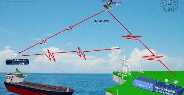
DGPS (Differential Global Positioning System)

Glossary:

Differential Global Positioning System: Improving GPS Accuracy

Differential Global Positioning System

In recent years, the Global Positioning System (GPS) has become an indispensable tool for a wide range of applications, from navigation in vehicles and smartphones to precision farming and surveying. However, despite its widespread use, GPS accuracy can still be limited in certain situations, such as in urban canyons or under dense tree cover. To address this issue, engineers and scientists have developed a technology called the Differential Global Positioning System (DGPS).

DGPS is a technique that improves the accuracy of GPS positioning by using a network of fixed reference stations. These reference stations are equipped with highly precise GPS receivers and known coordinates. They continuously measure and record GPS signals from satellites, and then calculate the difference between the observed GPS measurements and the known coordinates. This difference, known as the differential correction, is then transmitted to users via a radio signal or through the internet.

When a GPS receiver receives the differential correction, it can apply the necessary adjustments to its own measurements, significantly improving its accuracy. By using DGPS, GPS positioning errors can be reduced from several meters to a few centimeters. This level of accuracy is crucial for applications that require precise positioning, such as land surveying, construction site management, and autonomous vehicle guidance.

One of the key advantages of DGPS is its ability to correct for common sources of GPS errors, such as atmospheric effects and satellite clock errors. These errors can introduce significant inaccuracies in GPS measurements, but DGPS can effectively mitigate them by comparing the measurements from multiple reference stations. Additionally, DGPS can also account for ionospheric delays, which can cause signal propagation delays and affect GPS accuracy.

How GPS Works

The Global Positioning System, or GPS, is a satellite navigation system that provides location and time information to users anywhere on or near the Earth’s surface. The system consists of a network of satellites in space, ground-based control stations, and GPS receivers.

A GPS receiver works by receiving signals from multiple satellites and using the time it takes for the signals to reach the receiver to calculate the receiver’s distance from each satellite. By comparing the distances from multiple satellites, the receiver can determine its exact location.

The satellites in the GPS system transmit signals that contain information about the satellite’s location and the time the signal was transmitted. The receiver uses this information to calculate the distance from each satellite. The more satellites the receiver can receive signals from, the more accurate the location calculation will be.

To ensure accuracy, the GPS system uses a technique called trilateration. Trilateration involves measuring distance using the time it takes for a signal to travel from a satellite to the receiver. By determining the distance from multiple satellites, the receiver can pinpoint its location.

The GPS system also relies on ground-based control stations to monitor the satellites and make adjustments as needed. These control stations track the satellites’ orbits, check the accuracy of their clocks, and upload new information to them. This helps to ensure that the GPS system remains accurate and reliable.

Limitations of Conventional GPS

1. Signal blockage: The accuracy of conventional GPS systems is significantly affected by signal blockage. When GPS signals are obstructed by tall buildings, dense foliage, or other physical barriers, it can lead to inaccurate location readings. This limitation restricts the usability of GPS in urban areas or densely forested regions.

2. Signal multipath: Signal multipath occurs when GPS signals bounce off buildings or other objects before reaching the receiver. This phenomenon introduces timing errors, resulting in inaccurate position calculations. Areas with reflective surfaces or high-rise buildings are particularly prone to signal multipath, further reducing the accuracy of conventional GPS systems.

3. Atmospheric interference: The atmosphere can introduce delays and distortions to GPS signals, affecting the accuracy of position measurements. Weather conditions such as heavy rain, snow, or fog can attenuate or scatter GPS signals, leading to reduced accuracy. Additionally, ionospheric and tropospheric effects can introduce time delays in signal propagation, further impairing the precision of conventional GPS.

4. Limited number of satellites: Conventional GPS relies on a network of satellites to provide positioning information. However, the number of satellites visible at any given time may be limited, especially in areas with obstructed views of the sky. This limitation reduces the availability of GPS signals, leading to longer acquisition times and less accurate positioning.

5. Selective availability: In the past, the U.S. military intentionally introduced errors into GPS signals to limit their accuracy for non-military users. Although this practice known as selective availability was discontinued in 2000, some older GPS receivers may still be affected by residual errors. This limitation can impact the accuracy of conventional GPS devices, especially those that have not been updated or lack differential correction capabilities.

In summary, conventional GPS systems have various limitations that can impact their accuracy. Signal blockage, multipath, atmospheric interference, a limited number of satellites, and potential residual errors from selective availability can all contribute to inaccurate position calculations. To overcome these limitations, Differential Global Positioning System (DGPS) technology has been developed to enhance GPS accuracy by using reference stations to correct for signal errors and improve positioning precision.

What is Differential GPS?

Differential Global Positioning System (DGPS) is a technique that improves the accuracy of GPS signals by using a reference station with known coordinates. It is used to correct errors in GPS measurements caused by various factors such as atmospheric conditions, clock errors, and satellite orbit deviations.

In DGPS, the reference station measures its position accurately using alternative methods such as surveying or geodetic techniques. It then compares its known position with the GPS signal it receives, calculates the difference, and broadcasts this correction information to GPS receivers in the surrounding area.

GPS receivers equipped with DGPS capability can then apply these corrections to their own position calculations, resulting in more precise and accurate location data. By using DGPS, the accuracy of GPS measurements can be improved from several meters to within centimeters.

How Differential GPS Improves Accuracy

Differential GPS (DGPS) is a technology that improves the accuracy of the Global Positioning System (GPS) by taking into account various factors that can affect GPS signals. By using a reference station with known coordinates, DGPS compares the signals received from GPS satellites to the known location and calculates the error in the GPS signals. This error is then transmitted to GPS receivers to correct their measurements and provide more accurate positioning.

One way DGPS improves accuracy is by accounting for atmospheric conditions. GPS signals can be affected by factors such as ionospheric delay and tropospheric refraction, which can introduce errors in positioning. DGPS uses advanced algorithms to analyze the signals and calculate the impact of these atmospheric conditions, allowing for more precise positioning.

DGPS also helps reduce errors caused by satellite clock inaccuracies. Each GPS satellite has an atomic clock that serves as a reference for timing signals. However, these clocks can experience small variations, leading to timing errors in the signals. DGPS compares the timing signals from the reference station with the GPS signals and adjusts for any clock discrepancies, improving the accuracy of the positioning information.

Furthermore, DGPS takes into account other sources of error, such as multipath interference, which occurs when GPS signals bounce off objects and reach the receiver via multiple paths. By comparing the signals received at the reference station and the GPS receiver, DGPS can identify and correct for multipath interference, enhancing the accuracy of the positioning measurements.

In summary, Differential GPS improves accuracy by considering various factors that can affect GPS signals, such as atmospheric conditions, satellite clock inaccuracies, and multipath interference. By using a reference station with known coordinates, DGPS calculates the error in GPS signals and transmits the correction to GPS receivers, resulting in more precise positioning information.

Applications of Differential GPS

Differential Global Positioning System (DGPS) has a wide range of applications in various industries and fields. Its ability to improve GPS accuracy makes it a valuable tool in navigation, surveying, mapping, and other geospatial applications.

1. Navigation: One of the main applications of DGPS is in navigation. It is widely used in maritime navigation, where precise positioning is crucial to ensure the safety of vessels. DGPS provides accurate real-time position information, which helps ships and boats navigate through difficult waters, avoid obstacles, and reach their destinations more efficiently.

2. Surveying and Mapping: DGPS is extensively used in surveying and mapping applications. It allows surveyors and mappers to precisely measure and record the coordinates of various points on the Earth’s surface. This data is then used to create accurate maps, perform land surveys, and monitor changes in the environment. DGPS greatly improves the efficiency and accuracy of these tasks, reducing the need for manual measurements and calculations.

3. Precision Agriculture: DGPS technology is also employed in precision agriculture. Farmers use DGPS to accurately track and map the location of their crops, monitor soil conditions, and optimize the use of fertilizers and pesticides. This helps improve crop yields, reduce environmental impact, and increase overall efficiency in agricultural operations.

4. Emergency Response: DGPS plays a vital role in emergency response situations. Emergency services, such as police, fire, and ambulance, rely on accurate positioning data to locate and reach incidents quickly. DGPS provides real-time information, enabling emergency responders to navigate efficiently and effectively, especially in dense urban areas or remote locations.

5. Construction and Engineering: DGPS is widely used in the construction and engineering industry. It helps in precise positioning and alignment of structures, such as buildings, roads, bridges, and tunnels. DGPS data is used for site surveying, monitoring construction progress, and ensuring accurate placement of infrastructure components. This improves project efficiency, reduces errors, and minimizes rework.

Overall, the applications of Differential GPS are diverse and impactful across various industries. Its ability to enhance GPS accuracy makes it an essential tool in navigation, surveying, precision agriculture, emergency response, and construction and engineering.

Future Developments in Differential GPS Technology

Differential Global Positioning System (DGPS) technology has made significant advancements in improving the accuracy of GPS positioning. As technology continues to evolve, there are several future developments that are expected to further enhance the capabilities of differential GPS.

  • Real-time corrections: One of the main areas of development in differential GPS technology is the ability to provide real-time corrections. Currently, DGPS requires post-processing of data to obtain accurate positioning. However, future advancements aim to enable real-time corrections, allowing for more immediate and precise positioning.
  • Multi-constellation support: Another area of development is the integration of multiple satellite constellations. Currently, GPS systems primarily rely on the Global Positioning System (GPS) satellites. However, future differential GPS technology is expected to incorporate other satellite constellations such as GLONASS, Galileo, and BeiDou, thereby improving the availability and reliability of positioning data.
  • Improved signal processing: Advancements in signal processing techniques are also expected to enhance the accuracy of differential GPS. By improving the algorithms used to interpret satellite signals, future developments aim to reduce errors caused by factors such as atmospheric conditions and signal reflections, thereby improving the overall accuracy of GPS positioning.
  • Miniaturization and integration: As technology advances, there is a trend towards miniaturizing and integrating GPS receivers into various devices and applications. Future developments in differential GPS are expected to continue this trend, resulting in more compact and seamlessly integrated GPS systems. This could have significant implications for applications such as autonomous vehicles, drones, and wearable devices.

Overall, the future of differential GPS technology looks promising. With advancements in real-time corrections, multi-constellation support, improved signal processing, and miniaturization, the accuracy and availability of GPS positioning are expected to greatly improve, enabling a wide range of applications and services that rely on precise location information.


Video:

Contents:

Q&A:

What is Differential GPS technology?

Differential GPS (DGPS) is a satellite-based navigation system that provides accurate positioning information by correcting errors in the GPS signals. It uses a network of reference stations on the ground to broadcast correction information to GPS receivers.


What are the current limitations of Differential GPS technology?

One of the limitations of DGPS technology is that it requires a network of reference stations to provide accurate positioning information. This means that it may not be widely available in remote or rural areas. Additionally, DGPS signals can be affected by atmospheric conditions and obstructions, such as tall buildings or mountains, which can degrade the accuracy of the positioning information.


What are some future developments in Differential GPS technology?

One future development in DGPS technology is the use of additional satellite constellations, such as Galileo and BeiDou, in addition to the existing GPS constellation. This will increase the number of satellites available for positioning and improve the accuracy and availability of DGPS signals. Another development is the use of Real-Time Kinematic (RTK) techniques, which can provide centimeter-level accuracy by using a network of reference stations and precise carrier-phase measurements.


How can Differential GPS technology be used in the future?

Differential GPS technology has a wide range of potential applications in the future. It can be used for precise positioning and navigation in industries such as agriculture, surveying, construction, and transportation. It can also be used in autonomous vehicles, drones, and robotics to provide accurate localization and guidance. Furthermore, DGPS technology can be used in disaster management and emergency response systems to improve situational awareness and response coordination.


Comments

Leave a Reply

Solutions

[mwai_chatbot id="default"]